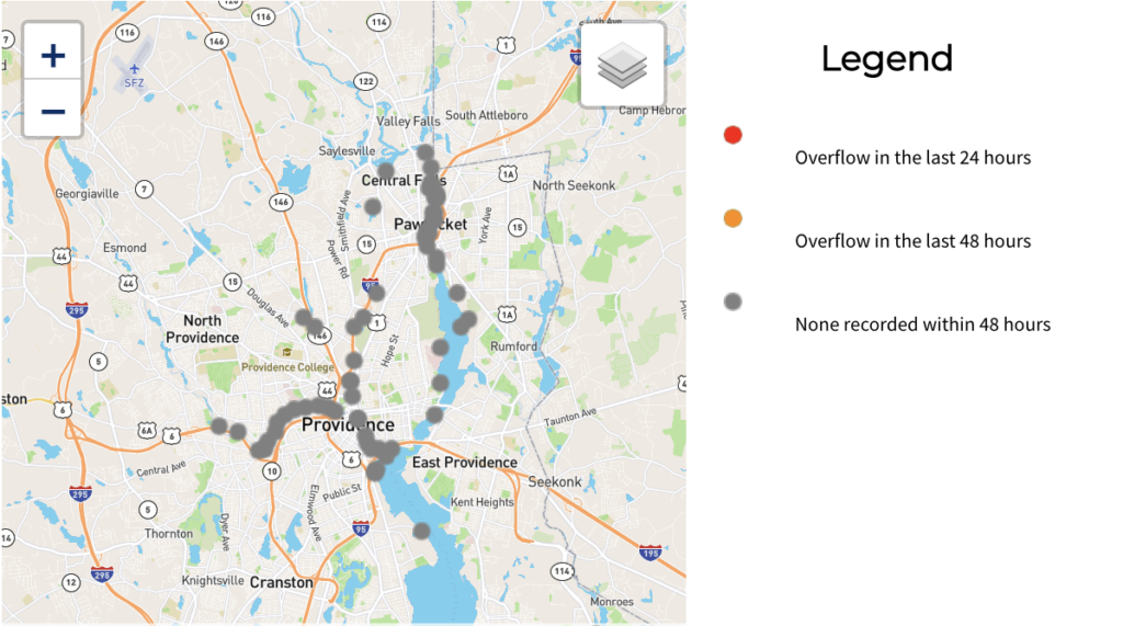
The Narragansett Bay Commission (NBC) has launched a live on-line map that tracks the status of combined sewer overflows (CSOs) and dry weather overflows (DWOs) into the Providence, Moshassuck, Woonasquatucket, West, and Seekonk Rivers.
“Reliable infrastructure—including pipes, treatment plants, trained and committed staff—is critical for clean water,” said NBC Chairman Vincent Mesolella, “and so is information. This map offers the public an important tool to see what’s happening in our rivers.”
The map, on the NBC’s website at https://narrabay.com/csomap, uses a real-time web-based notification system to provide advanced monitoring and will show overflows as they occur and keep them visible for up to 48 hours. The development of this interactive tool was required by the Rhode Island Department of Environmental Management and is based on efforts in other states and wastewater jurisdictions to notify the public of sewage overflows. The NBC map is the first of its kind in Rhode Island.
CSOs are the legacy of an historic sewer system. In the late 1800s, most larger cities across the nation built sewer systems to carry rain water and sewage in the same pipe. This is called a combined sewer. During dry weather conditions, the sewer system typically works very well. But, during heavy rainstorms, these combined flows can exceed the capacity of the sewer system and overflow into local rivers and Narragansett Bay. This is a combined sewer overflow, or CSO. CSOs violate the Federal Clean Water Act.
The NBC embarked on a three-phase project in 2001 to construct deep rock storage tunnels to temporarily store the flow from these CSOs during the storm and then transport it to the wastewater treatment facility when the storm ends. Phases I & II of NBC’s Comprehensive CSO Project have eliminated approximately 60% of CSOs to upper Narragansett Bay, at the rate of 1.1 billion gallons of combined sewage per year. Phase III, which begins construction in 2021, will eliminate another 38% resulting in an 80% reduction in shellfish bed closures, fewer bathing beach closures and a cleaner healthier Bay for all Rhode Islanders.
Development of the map included input from several stakeholder groups including the Woonasquatucket River Watershed Council, Save the Bay, and the Community Boating Center. “The Woonasquatucket River Watershed Council (WRWC) has been a long-time partner with the NBC to make the Woonasquatucket cleaner,” commented Alicia Lehrer, Executive Director of the WRWC. “We share a long-term vision of making the Woonasquatucket swimmable and fishable for all. We are so excited about NBC’s real-time CSO map so we can all watch together as the river improves and know when we need to be cautious.”
“Through the efforts of DEM, NBC and many partners, we have made incredible progress in cleaning up Rhode Island’s waters,” said DEM Director Janet Coit. “Today our bays, rivers, and coastal waters are cleaner and healthier, supporting our economy and increasing shellfishing and recreational opportunities. Kudos to NBC for implementing this new alert tool and for their investments in sewer system operations, maintenance, and monitoring.“
“I’m very proud of the work the NBC team, in conjunction with DEM and our stakeholders, to bring this project to fruition,” Mesolella added. “It speaks to the high quality and reliability of the NBC’s flow monitoring program and enables more Rhode Islanders to safely experience and enjoy our rivers and bay, which is of course the goal we’re all striving for.”
The website also provides information about the NBC sewer system, the possible causes of sewer overflows, and general language about recreation and contact with urban rivers

